|

| |
|
|
|
|
| Rugged field computer
compatible with all Trimble AgGPS receivers
and Parallel Swathing Options
 The
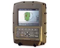
AgGPS® 170 Field Computer running
AgGPS® FieldManager software
is a top-of-the-line field information management solution that adds the
power of record-keeping, field mapping, variable rate management, and soil
sampling to Trimble AgGPS receivers and enhances the precision
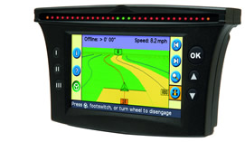
guidance of the AgGPS® Parallel Swathing Option or the
AgGPS® EZ-Guide™
system.
The AgGPS 170 Field Computer facilitates any agricultural operation
by the custom applicator, agribusiness operator, or farmer including
spreading, spraying, planting and even precision cultivation and seed bed
preparation.
The rugged design of the AgGPS 170 Field Computer ensures reliable
operation even under extreme environmental conditions. Soil sampling,
variable rate application, and planting are also possible with the AgGPS
170 Field Computer. During applications and planting, farmers can easily map
features such as weed spots, plant variety areas, or hazards. The system
also provides sophisticated automated record-keeping--- ideal to automate
customer billing, communications with environmental authorities, and GIS
data analysis. Combine the system with the AgGPS 214 high accuracy
Real-time Kinematic (RTK)
receiver to record centimeter-level elevations for field topographic mapping.
 | 5.5 inch color display readable in direct sunlight or at night |
|
| rugged design for extreme temperatures and humidity |
|
| field and on-the-go point, line, and area feature mapping |
|
| variable rate management and as-applied logging |
|
| soil sampling |
|
| application coverage logging |
|
| data integrity protection: if power is lost, all data is saved by a
backup battery |
|
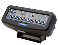
| add the modular AgGPS 170 Field Computer to your AgGPS
Parallel Swathing Option system |
|
| compatible with all of Trimble's AgGPS receivers |
|
| all data stored on CompactFlash data cards in ESRI Shapefile format |
|
| software for aerial-based operations included |
|
|